
Totes Gebirge
Beschrijving
 Like many other ranges in the Northern Limestone Alps, the Totes Gebirge - Dead Mountains - is formed by a karstic plateau with steep sides. Highest summit is Großer Priel, 2515 m. For the mountain hiker, several crossings of the plateau are waiting. There are about 30 huts in this area alone! Admittedly, the Totes Gebirge has no glaciers, like the neighboring Dachstein. But the rugged character, the sharp limestone formations, erosion, the many sink-holes, makes it a fine area for the seasoned hiker.
Kaart

Paden in deze regio
Links
Feiten
Verslagen
Gidsen en kaarten
Overnachting
Organisaties
Reisorganisaties
GPS
Anders
Boeken

De Zwerver
Netherlands
2022
Netherlands
2022

De Zwerver
Netherlands
2023
Netherlands
2023


De Zwerver
Netherlands
2022
Netherlands
2022
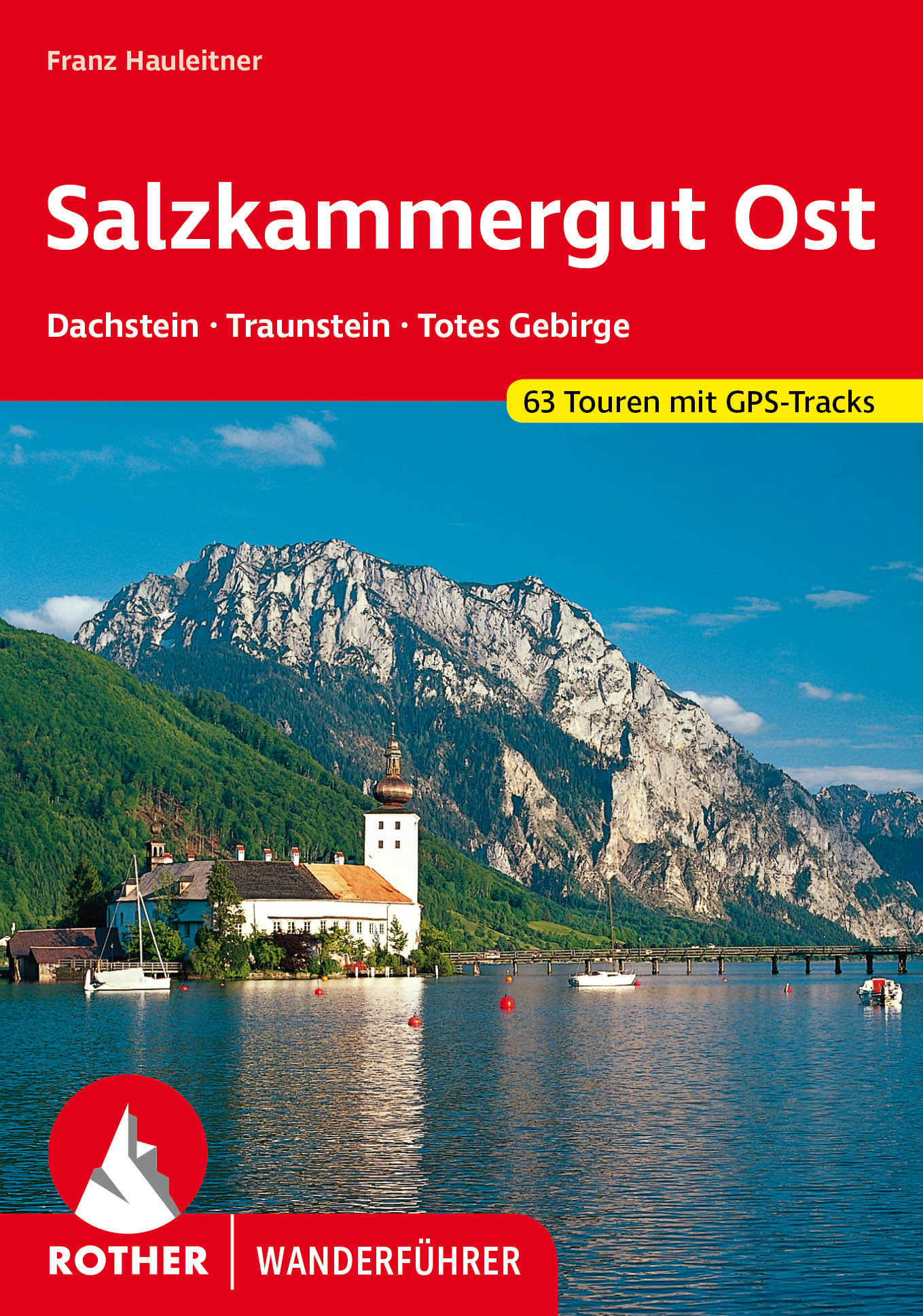
- Wandelgids Salzkammergut Ost | Rother Bergverlag
- Uitstekende wandelgids met een groot aantal dagtochten in dal en hooggebergte. Met praktische informatie en beperkt kaartmateriaal! Wandelingen in verschillende zwaarte weergegeven in rood/blauw/zwart. Das Salzkammergut zählt zu den reizvollsten Urlaubsgebieten Europas. Wo sonst vereinen sich unterschiedliche Landschaftsformen zu einem so... Read more

De Zwerver
Netherlands
2018
Netherlands
2018
- Wandelgids Tourist route E4 in Bulgaria | Oilaripi
- Verrassend goede wandelgids van een deel van de E4 in Bulgarije. Goede kaarten, hoogteprofielen, prima beschrijvingen en praktische informatie maken het een volwaardige wandelgids die je in eerste instantie van dit gebied niet zou verwachten. Guidebook along the main ridge of the great alpine route E4 in Bulgaria, also known as �the fiv... Read more


Bol.com
Netherlands
Netherlands
- Hiking in Switzerland
- This is the official guidebook to the Swiss section of the Via Alpina (National Route 1), published by the Swiss Hiking Federation. The Via Alpina is a network of five long-distance hiking routes which cross eight Alpine countries from Trieste to Monaco - over 5,000 kilometres of hiking trails in total. On Swiss soil, National Route 1 Via... Read more
- Also available from:
- Bol.com, Belgium
Bol.com
Belgium
Belgium
- Hiking in Switzerland
- This is the official guidebook to the Swiss section of the Via Alpina (National Route 1), published by the Swiss Hiking Federation. The Via Alpina is a network of five long-distance hiking routes which cross eight Alpine countries from Trieste to Monaco - over 5,000 kilometres of hiking trails in total. On Swiss soil, National Route 1 Via... Read more

De Zwerver
Netherlands
2015
Netherlands
2015
- Wandelgids The high mountains of Crete - Kreta | Cicerone
- Guidebook of walking routes in Crete's mountains, covering the Lefka Ori (White Mountains), Mount Ida (the Psiloritis range), the Lassithi mountains and E4 trail. Each of the 87 walks is graded, in a range between 2 and 28km with various longer options, covering a multitude of terrains from rugged mountain ridges to forested crags and beaches. Read more
- Also available from:
- Bol.com, Netherlands
- Bol.com, Belgium
- Stanfords, United Kingdom
- The Book Depository, United Kingdom

Bol.com
Netherlands
2015
Netherlands
2015
- The high mountains of Crete
- Guidebook to walking and trekking the high mountains of Crete. The largest of the Greek Islands, Crete's mountains provide breathtaking walking and wilderness on this popular island. The routes in this guidebook are graded for difficulty and range from short, easy strolls to challenging, multi-day treks, providing options for all walkers. In... Read more
Bol.com
Belgium
2015
Belgium
2015
- The high mountains of Crete
- Guidebook to walking and trekking the high mountains of Crete. The largest of the Greek Islands, Crete's mountains provide breathtaking walking and wilderness on this popular island. The routes in this guidebook are graded for difficulty and range from short, easy strolls to challenging, multi-day treks, providing options for all walkers. In... Read more

Stanfords
United Kingdom
2015
United Kingdom
2015
- Crete High Mountain Walks, the White Mountains, Mt Ida and Lassithi - 3rd ed.
- The High Mountains of Crete is Loraine Wilson’s authoritative Cicerone guide to the best walking routes in Crete’s mountainous regions. The guide covers walks in the well-known Samaria Gorge and the other dramatic gorges and numerous peaks rising to over 2100m, alongside high mountain plains, forested crags, massive cliffs and remote beaches.... Read more

The Book Depository
United Kingdom
2015
United Kingdom
2015
- The High Mountains of Crete
- The White Mountains, Psiloritis and Lassithi Mountains Read more

Bol.com
Netherlands
Netherlands
- WF5421 Allgäu, Allgäuer Alpen Kompass
- De Kompass wandelgids + kaart geeft een overzicht van alle wandelroutes in het gebied met nauwkeurige routeaanwijzingen en hoogteaanduidingen, De extra grote kaart, schaal 1:35 000, is ideaal om van te voren uw route uit te stippelen en om onderweg te gebruiken • naast de bekende bestemmingen, worden ook de minder bekende vermeld • openbaar... Read more
- Also available from:
- Bol.com, Belgium
Bol.com
Belgium
Belgium
- WF5421 Allgäu, Allgäuer Alpen Kompass
- De Kompass wandelgids + kaart geeft een overzicht van alle wandelroutes in het gebied met nauwkeurige routeaanwijzingen en hoogteaanduidingen, De extra grote kaart, schaal 1:35 000, is ideaal om van te voren uw route uit te stippelen en om onderweg te gebruiken • naast de bekende bestemmingen, worden ook de minder bekende vermeld • openbaar... Read more

Bol.com
Netherlands
Netherlands
- Over the Top & Back Again
- Book of the Year Bronze Award 2010 (travel essays category), ForeWord Magazine After hiking some of the world's great trails, Brandon Wilson was excited to hear about the Via Alpina, paths running across eight countries on the backbone of the Alps. Besides promising immersion into Alpine life and wilderness, it was the ultimate adventure. It... Read more
- Also available from:
- Bol.com, Belgium
Bol.com
Belgium
Belgium
- Over the Top & Back Again
- Book of the Year Bronze Award 2010 (travel essays category), ForeWord Magazine After hiking some of the world's great trails, Brandon Wilson was excited to hear about the Via Alpina, paths running across eight countries on the backbone of the Alps. Besides promising immersion into Alpine life and wilderness, it was the ultimate adventure. It... Read more

Bol.com
Netherlands
2014
Netherlands
2014
- Walking in the Bavarian Alps
- Guidebook describing a both valley and mountain walks and treks in the Bavarian Alps. 85 walks are covered, including graded mountain routes, gentler valley walks, hut-to-hut routes and two multi-day tours, arranged by region with practical information on transport, accommodation and the like. Since the last edition of this guide many of the... Read more
- Also available from:
- Bol.com, Belgium
Bol.com
Belgium
2014
Belgium
2014
- Walking in the Bavarian Alps
- Guidebook describing a both valley and mountain walks and treks in the Bavarian Alps. 85 walks are covered, including graded mountain routes, gentler valley walks, hut-to-hut routes and two multi-day tours, arranged by region with practical information on transport, accommodation and the like. Since the last edition of this guide many of the... Read more

Bol.com
Netherlands
Netherlands
- Over the Top & Back Again
- Book of the Year Bronze Award 2010 (travel essays category), ForeWord Magazine After hiking some of the world's great trails, Brandon Wilson was excited to hear about the Via Alpina, paths running across eight countries on the backbone of the Alps. Besides promising immersion into Alpine life and wilderness, it was the ultimate adventure. It... Read more
- Also available from:
- Bol.com, Belgium
Bol.com
Belgium
Belgium
- Over the Top & Back Again
- Book of the Year Bronze Award 2010 (travel essays category), ForeWord Magazine After hiking some of the world's great trails, Brandon Wilson was excited to hear about the Via Alpina, paths running across eight countries on the backbone of the Alps. Besides promising immersion into Alpine life and wilderness, it was the ultimate adventure. It... Read more

Bol.com
Netherlands
2017
Netherlands
2017
- The Swiss alpine pass route - Via Alpina route 1
- This guidebook presents the stunning Alpine Pass Route, now fully waymarked as Via Alpina 1. The 360km trail traverses Switzerland from east to west, from Sargans near the Liechtenstein border to Montreux on Lac Léman (Lake Geneva). Crossing sixteen Alpine passes, it showcases some of the country's most breathtaking mountain landscapes,... Read more
- Also available from:
- Bol.com, Belgium
- Stanfords, United Kingdom
Bol.com
Belgium
2017
Belgium
2017
- The Swiss alpine pass route - Via Alpina route 1
- This guidebook presents the stunning Alpine Pass Route, now fully waymarked as Via Alpina 1. The 360km trail traverses Switzerland from east to west, from Sargans near the Liechtenstein border to Montreux on Lac Léman (Lake Geneva). Crossing sixteen Alpine passes, it showcases some of the country's most breathtaking mountain landscapes,... Read more

Stanfords
United Kingdom
2017
United Kingdom
2017
- The Swiss Alpine Pass Route - via Alpina Route 1: Trekking East to West Across Switzerland
- This guidebook presents the stunning Alpine Pass Route, now fully waymarked as Via Alpina 1. The 360km trail traverses Switzerland from east to west, from Sargans near the Liechtenstein border to Montreux on Lac Leman (Lake Geneva). Crossing sixteen Alpine passes, it showcases some of the country`s most breathtaking mountain landscapes,... Read more

Bol.com
Netherlands
2019
Netherlands
2019
- WF5966 Julische Alpen mit Karte Kompass
- De Kompass wandelgids + kaart geeft een overzicht van alle wandelroutes in het gebied met nauwkeurige routeaanwijzingen en hoogteaanduidingen, De extra grote kaart, schaal 1:35 000, is ideaal om van te voren uw route uit te stippelen en om onderweg te gebruiken; naast de bekende bestemmingen, worden ook de minder bekende vermeld; openbaar... Read more
- Also available from:
- Bol.com, Belgium
Bol.com
Belgium
2019
Belgium
2019
- WF5966 Julische Alpen mit Karte Kompass
- De Kompass wandelgids + kaart geeft een overzicht van alle wandelroutes in het gebied met nauwkeurige routeaanwijzingen en hoogteaanduidingen, De extra grote kaart, schaal 1:35 000, is ideaal om van te voren uw route uit te stippelen en om onderweg te gebruiken; naast de bekende bestemmingen, worden ook de minder bekende vermeld; openbaar... Read more
Kaarten

De Zwerver
Netherlands
2016
Netherlands
2016
- Wandelgids The Cretan Way E4 | Anavasi
- The Cretan Way is a 500km walking route which takes you from east to west across the varied and spectacular landscapes of Crete. It is the ideal way to discover the rural, mountainous and costal regions of this incredible island. This guide is based on a 28-day walk.This guide includes practical information, maps at a scale of 1:25.000 of... Read more
- Also available from:
- Stanfords, United Kingdom

Stanfords
United Kingdom
2016
United Kingdom
2016
- The Cretan Way - A 28 Day Walk
- The Cretan Way is a 500km walking route which takes you from east to west across the varied and spectacular landscapes of Crete. It is the ideal way to discover the rural, mountainous and costal regions of this incredible island. This guide is based on a 28-day walk.This guide includes practical information, maps at a scale of 1:25.000 of... Read more

De Zwerver
Netherlands
Netherlands
- Wandelkaart 06 Monviso | IGC - Istituto Geografico Centrale
- Monviso / Monte Viso cross-border area with coverage from Châteaux Queyras to Sampeyre and from the Grand Queyron to the Aiguille de Chambeyron in a series contoured hiking maps at 1:50,000 with local trails, long-distance footpaths, mountain accommodation, etc. from the Turin based Istituto Geografico Centrale.Maps in this series have contours... Read more
- Also available from:
- Stanfords, United Kingdom

Stanfords
United Kingdom
United Kingdom
- Monviso IGC 6
- Monviso / Monte Viso cross-border area with coverage from Châteaux Queyras to Sampeyre and from the Grand Queyron to the Aiguille de Chambeyron in a series contoured hiking maps at 1:50,000 with local trails, long-distance footpaths, mountain accommodation, etc. from the Turin based Istituto Geografico Centrale.Maps in this series have contours... Read more

De Zwerver
Netherlands
Netherlands
- Wandelkaart 07 Valli Maira, grana e stura | IGC - Istituto Geografico Centrale
- Maira, Grana and Stura Valleys, map no. 7, in a series contoured hiking maps at 1:50,000 with local trails, long-distance footpaths, mountain accommodation, etc. from the Turin based Istituto Geografico Centrale covering the Italian Alps and Piedmont, the lakes and northern Lombardy, and the Italian Riviera.The maps have contours at 50m... Read more
- Also available from:
- Stanfords, United Kingdom

Stanfords
United Kingdom
United Kingdom
- Maira, Grana and Stura Valleys IGC 7
- Maira, Grana and Stura Valleys in a series contoured hiking maps at 1:50,000 with local trails, long-distance footpaths, mountain accommodation, etc. from the Turin based Istituto Geografico Centrale.Maps in this series have contours at 50m intervals, enhanced by shading and graphic relief. An overprint highlights local footpaths and... Read more

De Zwerver
Netherlands
Netherlands
- Wandelkaart 1 Stara Planina gebergte | Domino
- Stara Planina Central: Zlatitsa to Kalofer map at 1:50,000 from Bulgarian publishers Domino, contoured and GPS compatible, with hiking trails, accommodation options including a list of local mountain refuges, etc. The map is double-sided and covers the mountains from just west of Ribaritsa and Zlatitsa eastwards beyond Kalofer to the peak of... Read more
- Also available from:
- Stanfords, United Kingdom

Stanfords
United Kingdom
United Kingdom
- Stara Planina Central: Zlatitsa to Kalofer Domino Map
- Stara Planina Central: Zlatitsa to Kalofer map at 1:50,000 from Bulgarian publishers Domino, contoured and GPS compatible, with hiking trails, accommodation options including a list of local mountain refuges, etc. The map is double-sided and covers the mountains from just west of Ribaritsa and Zlatitsa eastwards beyond Kalofer to the peak of... Read more

De Zwerver
Netherlands
Netherlands
- Wandelkaart 2.4 Nafpaktos - Panaitoliko - Karpenisi | Anavasi
- Prespa - Vitsi – Voras area of northern Greece at 1:50,000 on a light, waterproof and tear-resistant, GPS compatible, contoured map from Anavasi, with recommendations for three hiking trails and notes on the E4 and E6 cross-European trails. The map is double-sided; coverage in the west starts from the Prespa Lake on the border with Albania and... Read more
De Zwerver
Netherlands
Netherlands
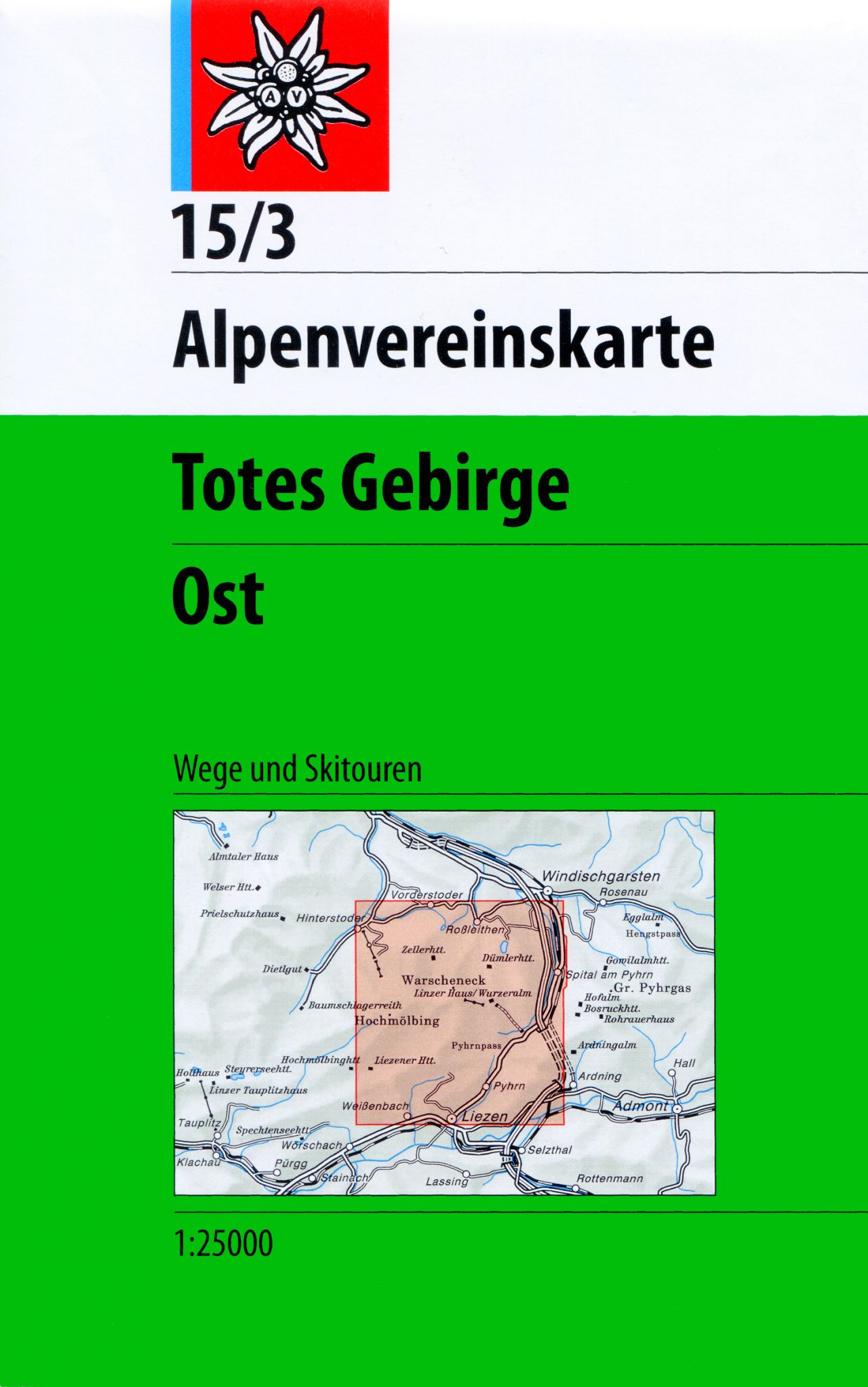
- Wandelkaart 15/3 Alpenvereinskarte Totes Gebirge - Ost | Alpenverein
- Totes Gebirge East area of the Alps in a combined hiking and ski edition at 1:25,000 from a series of detailed, GPS compatible maps published by the DAV - Deutscher Alpenverein and produced by the German and Austrian Alpine Clubs using cartography from their respective survey organizations. Maps in this series have topography vividly presented... Read more
- Also available from:
- Stanfords, United Kingdom

Stanfords
United Kingdom
United Kingdom
- Totes Gebirge East Alpenverein KOMBI Map 15/3
- Totes Gebirge East area of the Alps in a combined hiking and ski edition at 1:25,000 from a series of detailed, GPS compatible maps published by the DAV - Deutscher Alpenverein and produced by the German and Austrian Alpine Clubs using cartography from their respective survey organizations. Maps in this series have topography vividly presented... Read more

De Zwerver
Netherlands
Netherlands
- Wandelkaart 08 Alpi marittime e Liguri | IGC - Istituto Geografico Centrale
- A cross-border area of the Maritime and Ligurian Alps at 1:50,000, with coverage on the Italian side including Limone, Alpi Maritime PN and Alta Valle Pesio e Tanaro PN, plus in France Tende, Vallée des Merveilles and Saorge, in a series contoured hiking maps with local trails, long-distance footpaths, mountain accommodation, etc. from the... Read more
- Also available from:
- Stanfords, United Kingdom

Stanfords
United Kingdom
United Kingdom
- Maritime and Ligurian Alps IGC 8
- A cross-border area of the Maritime and Ligurian Alps at 1:50,000, with coverage on the Italian side including Limone, Alpi Maritime PN and Alta Valle Pesio e Tanaro PN, plus in France Tende, Vallée des Merveilles and Saorge, in a series contoured hiking maps with local trails, long-distance footpaths, mountain accommodation, etc. from the... Read more

De Zwerver
Netherlands
Netherlands
- Wandelkaart 09 Ivrea, Biella e Bassa Valle d'Aosta | IGC - Istituto Geografico Centrale
- Ivrea - Biela - Lower Aosta Valley, map no. 9, in a series contoured hiking maps at 1:50,000 with local trails, long-distance footpaths, mountain accommodation, etc. from the Turin based Istituto Geografico Centrale covering the Italian Alps and Piedmont, the lakes and northern Lombardy, and the Italian Riviera.The maps have contours at 50m... Read more
- Also available from:
- Stanfords, United Kingdom

Stanfords
United Kingdom
United Kingdom
- Ivrea - Biela - Lower Aosta Valley 50K IGC Map No. 9
- Ivrea - Biela - Lower Aosta Valley area in a series contoured hiking maps at 1:50,000 with local trails, long-distance footpaths, mountain accommodation, etc. from the Turin based Istituto Geografico Centrale. Maps in this series have contours at 50m intervals, enhanced by shading and graphic relief. An overprint highlights local footpaths and... Read more

De Zwerver
Netherlands
Netherlands
- Wandelkaart 2 Stara Planina gebergte | Domino
- Stara Planina Central: Uzana to Vratnik map at 1:50,000 from Bulgarian publishers Domino, contoured and GPS compatible, with hiking trails, accommodation options including a list of local mountain refuges, etc. The map is double-sided and covers the mountains from just west of the Uzana massif, the geographical centre of Bulgaria, eastwards to... Read more
- Also available from:
- Stanfords, United Kingdom

Stanfords
United Kingdom
United Kingdom
- Stara Planina Central: Uzana to Vratnik Domino Map
- Stara Planina Central: Uzana to Vratnik map at 1:50,000 from Bulgarian publishers Domino, contoured and GPS compatible, with hiking trails, accommodation options including a list of local mountain refuges, etc. The map is double-sided and covers the mountains from just west of the Uzana massif, the geographical centre of Bulgaria, eastwards to... Read more

De Zwerver
Netherlands
Netherlands
- Wandelkaart - Fietskaart - Wegenkaart - landkaart 448 Western Crete - Kreta West | Terrain maps
- Western Crete at 1:100,000 on an indexed, GPS compatible road map from Terrain Editions, printed on light, waterproof and tear-resistant plastic paper, with a street plan of central Chania.This title is part of a series which covers Crete in three sheets. The maps have contours at 100m intervals, enhanced by relief shading with spot heights and... Read more
- Also available from:
- Stanfords, United Kingdom

Stanfords
United Kingdom
United Kingdom
- Western Crete Terrain Editions 448
- Western Crete at 1:100,000 on an indexed, GPS compatible road map from Terrain Editions, printed on light, waterproof and tear-resistant plastic paper, with a street plan of central Chania.This title is part of a series which covers Crete in three sheets. The maps have contours at 100m intervals, enhanced by relief shading with spot heights and... Read more

De Zwerver
Netherlands
Netherlands
- Wandelkaart 14 San Remo, imperia Monte Carlo | IGC - Istituto Geografico Centrale
- The westernmost part of the Italian Riviera with coverage extending from Monte Carlo to Imperia and northwards to Tende, in a series contoured hiking maps at 1:50,000 with local trails, long-distance footpaths, mountain accommodation, etc. from the Turin based Istituto Geografico Centrale.Maps in this series have contours at 50m intervals,... Read more
- Also available from:
- Stanfords, United Kingdom

Stanfords
United Kingdom
United Kingdom
- San Remo - Imperia - Monte Carlo IGC 14
- The westernmost part of the Italian Riviera with coverage extending from Monte Carlo to Imperia and northwards to Tende, in a series contoured hiking maps at 1:50,000 with local trails, long-distance footpaths, mountain accommodation, etc. from the Turin based Istituto Geografico Centrale.Maps in this series have contours at 50m intervals,... Read more

De Zwerver
Netherlands
Netherlands
- Wandelkaart 12 Laghi Maggiore, d'Orta e di Varese | IGC - Istituto Geografico Centrale
- Lake Maggiore - Lake Orta - Lake Varase, map no. 12, in a series contoured hiking maps at 1:50,000 with local trails, long-distance footpaths, mountain accommodation, etc. from the Turin based Istituto Geografico Centrale covering the Italian Alps and Piedmont, the lakes and northern Lombardy, and the Italian Riviera.The maps have contours at... Read more

- Also available from:
- Stanfords, United Kingdom

Stanfords
United Kingdom
United Kingdom
- Langhe Meridionali IGC 18
- The southern part of the Langhe region of Piedmont, famous for its wines, cheeses, and truffles, in a series contoured hiking maps at 1:50,000 with local trails, long-distance footpaths, mountain accommodation, etc. from the Turin based Istituto Geografico Centrale.Maps in this series have contours at 50m intervals, enhanced by shading and... Read more

De Zwerver
Netherlands
Netherlands
- Wandelkaart 24 Il Cuneese - Cuneo | IGC - Istituto Geografico Centrale
- Il Cuneese, map no. 24, in a series contoured hiking maps at 1:50,000 with local trails, long-distance footpaths, mountain accommodation, etc. from the Turin based Istituto Geografico Centrale covering the Italian Alps and Piedmont, the lakes and northern Lombardy, and the Italian Riviera.The maps have contours at 50m intervals, enhanced by... Read more
- Also available from:
- Stanfords, United Kingdom

Stanfords
United Kingdom
United Kingdom
- Il Cuneese: Cuneo - Saluzzo - Carmagnola 75K IGC Map No. 24
- Il Cuneese area of Piedmont, including Cuneo, Saluzzo and Carmagnola, at 1:75,000 in a series contoured hiking maps with local trails, long-distance footpaths, mountain accommodation, etc. from the Turin based Istituto Geografico Centrale. This title also includes an overprint showing cycle routes.Maps in this series have contours at 50m... Read more

De Zwerver
Netherlands
Netherlands
- Wandelkaart 3 Stara Planina gebergte | Domino
- Stara Planina Western: Belogradchik to Berkovita map at 1:50,000 from Bulgarian publishers Domino, contoured and GPS compatible, with hiking trails, accommodation options including a list of local mountain refuges, etc. The map is double-sided and covers the mountains from the peak of Byala Voda near Belogradchik eastwards to just beyond... Read more
- Also available from:
- Stanfords, United Kingdom

Stanfords
United Kingdom
United Kingdom
- Stara Planina Western: Belogradchik to Berkovita Domino Map
- Stara Planina Western: Belogradchik to Berkovita map at 1:50,000 from Bulgarian publishers Domino, contoured and GPS compatible, with hiking trails, accommodation options including a list of local mountain refuges, etc. The map is double-sided and covers the mountains from the peak of Byala Voda near Belogradchik eastwards to just beyond... Read more