De Zwerver
Netherlands
» Click to open
Stanfords
United Kingdom
  • Hoher Freschen Swisstopo 228
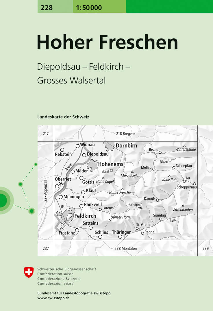
  • Hoher Freschen, map No. 228, in the standard topographic survey of Switzerland at 1:50,000 from Swisstopo, i.e. without the special overprint highlighting walking trails, local bus stops, etc, presented in Swisstopo’s hiking editions of the 50K survey. The map covers mainly Austria, extending east to Au.Highly regarded for their superb use of... Read more
» Click to close
De Zwerver
Netherlands
» Click to open
Stanfords
United Kingdom
  • Zell am See - Kaprun - Glemmtal - Unterpinzgau K+F Outdoor Map 11
  • Zell am See - Kaprun - Glemmtal - Unterpinzgau area of the Tyrol at 1:35,000 on a GPS compatible, double-sided map from Kümmerly+Frey printed on sturdy, waterproof and tear-resistant synthetic paper; contoured, with hiking, cycling and ski routes, accommodation facilities, locations for other recreational activities, etc.Maps in the K+F... Read more
» Click to close
De Zwerver
Netherlands
» Click to open
Stanfords
United Kingdom
  • Piz Lad Swisstopo 1199bis
  • Map No. 1199 bis, Piz Lad, in the topographic survey of Switzerland at 1:25,000 from Bundesamt für Landestopographie (swisstopo), covering the whole country on 247 small format sheets, with special larger maps published for popular regions including some titles now available in hiking versions.Highly regarded for their superb use of graphic... Read more
» Click to close
De Zwerver
Netherlands
2023
De Zwerver
Netherlands
» Click to open
Stanfords
United Kingdom
  • Hochschwabgruppe Alpenverein KOMBI Map 18
  • Hochschwabgruppe area of the Alps in a combined hiking and ski edition at 1:50,000 from a series of detailed, GPS compatible maps published by the DAV - Deutscher Alpenverein and produced by the German and Austrian Alpine Clubs using cartography from their respective survey organizations. Maps in this series have topography vividly presented by... Read more
» Click to close
De Zwerver
Netherlands
2016
De Zwerver
Netherlands
» Click to open
Stanfords
United Kingdom
  • Innsbruck - Brenner - Stubaital - Gschnitztal K+F Outdoor Map 7
  • Innsbruck - Brenner - Stubaital – Gschnitztal area of the Tyrol at 1:35,000 on a GPS compatible, double-sided map from Kümmerly+Frey printed on sturdy, waterproof and tear-resistant synthetic paper; contoured, with hiking, cycling and ski routes, accommodation facilities, locations for other recreational activities, etc.Maps in the K+F... Read more
» Click to close
De Zwerver
Netherlands
De Zwerver
Netherlands
2024
De Zwerver
Netherlands
» Click to open
Stanfords
United Kingdom
  • Hochkönig - Hagengebirge Alpenverein KOMBI Map 10/2
  • Hochkönig - Hagengebirge area of the Alps in a combined hiking and ski edition at 1:25,000 from a series of detailed, GPS compatible maps published by the DAV - Deutscher Alpenverein and produced by the German and Austrian Alpine Clubs using cartography from their respective survey organizations. Maps in this series have topography vividly... Read more
» Click to close
De Zwerver
Netherlands
De Zwerver
Netherlands
De Zwerver
Netherlands
» Click to open
Stanfords
United Kingdom
  • Innsbruck and Environs Alpenverein Map 31/5
  • Innsbruck and the surrounding area of the Alps in a hiking edition at 1:50,000 from a series of detailed, GPS compatible maps published by the DAV - Deutscher Alpenverein and produced by the German and Austrian Alpine Clubs using cartography from their respective survey organizations. Maps in this series have topography vividly presented by... Read more
» Click to close
De Zwerver
Netherlands
De Zwerver
Netherlands