De Zwerver
Netherlands
De Zwerver
Netherlands
De Zwerver
Netherlands
» Click to open
Stanfords
United Kingdom
  • Bormio - Livigno - Alta Valtellina Kompass 96
  • Map No. 96, Bormio - Livigno - Corna di Campo, from Kompass printed on sturdy, waterproof and tear-resistant synthetic paper in a series of walking maps of selected areas of Italy at 1:50,000, with hiking routes on a topographic base, various types of accommodation, recreational facilities, places of interest, etc. Kompass are Europe’s largest... Read more
» Click to close
De Zwerver
Netherlands
De Zwerver
Netherlands
De Zwerver
Netherlands
2018
De Zwerver
Netherlands
De Zwerver
Netherlands
2022
De Zwerver
Netherlands
2018
De Zwerver
Netherlands
De Zwerver
Netherlands
De Zwerver
Netherlands
» Click to open
Stanfords
United Kingdom
  • Florence - Siena - Chianti Kompass 2458
  • Florence - Siena - Chianti area on a double-sided map at 1:50,000 from Kompass, printed on durable, waterproof and tear-resistant synthetic paper. Coverage includes Val di Pesa, Val d’Elsa, Monteriggioni, etc. Contours are at 40m intervals, with a 2-km UTM grid. Extensive overprint includes GEA - Grande Escursione Appenninica, Sentiero Italia,... Read more
» Click to close
De Zwerver
Netherlands
2021
» Click to open
Stanfords
United Kingdom
2021
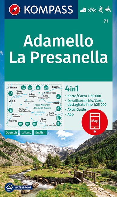
  • Adamello - La Presanella Kompass 71
  • Adamello - La Presanella area just north of Lake Garda on a GPS compatible hiking and recreational map at 1:50,000 from Kompass, printed on durable, waterproof and tear-resistant synthetic paper. KOMPASS HIKING MAPS OF ITALY: this title is part of an extensive series of walking maps from Kompass covering selected areas of Italy at mainly... Read more
» Click to close
De Zwerver
Netherlands
» Click to open
Stanfords
United Kingdom
  • Rovereto - Monte Pasubio Kompass 101
  • Map No. 101, Rovereto - Monte Pasubio, from Kompass in a series of walking maps of selected areas of Italy at 1:50,000, with hiking routes on a topographic base, various types of accommodation, recreational facilities, places of interest, etc. Kompass are Europe’s largest publishers of walking maps, with extensive coverage of hiking areas in... Read more
» Click to close
De Zwerver
Netherlands
» Click to open
Stanfords
United Kingdom
  • Lake Garda - Monte Baldo Kompass 102
  • Lake Garda and the surrounding mountain on a waterproof and tear-resistant, contoured and GPS compatible map at 1:50,000 from Kompass with hiking and cycling trails, plus on the reverse a panorama map of the area, street plans of central Verona, Riva del Garda and Peschiera, and extensive English language to the area. Contours are at 40m... Read more
» Click to close