
De Zwerver
Netherlands

Stanfords
United Kingdom
- Matterhorn / M. Cervino - Monte Rosa IGC 5
- The Italian side of the Matterhorn and Monte Rosa, with coverage extending from Zermatt to Aosta, in a series contoured hiking maps at 1:50,000 with local trails, long-distance footpaths, mountain accommodation, etc. from the Turin based Istituto Geografico Centrale. Maps in this series have contours at 50m intervals, enhanced by shading and... Read more

De Zwerver
Netherlands

Stanfords
United Kingdom
- Il Canavese: Ivrea to Chiavasso 50K IGC Map No. 21
- Il Canavesea area including Ivrea and Chiavasso in a series contoured hiking maps at 1:50,000 with local trails, long-distance footpaths, mountain accommodation, etc. from the Turin based Istituto Geografico Centrale. This title also shows cycle routes.Maps in this series have contours at 50m intervals, enhanced by shading and graphic relief.... Read more
De Zwerver
Netherlands

Stanfords
United Kingdom
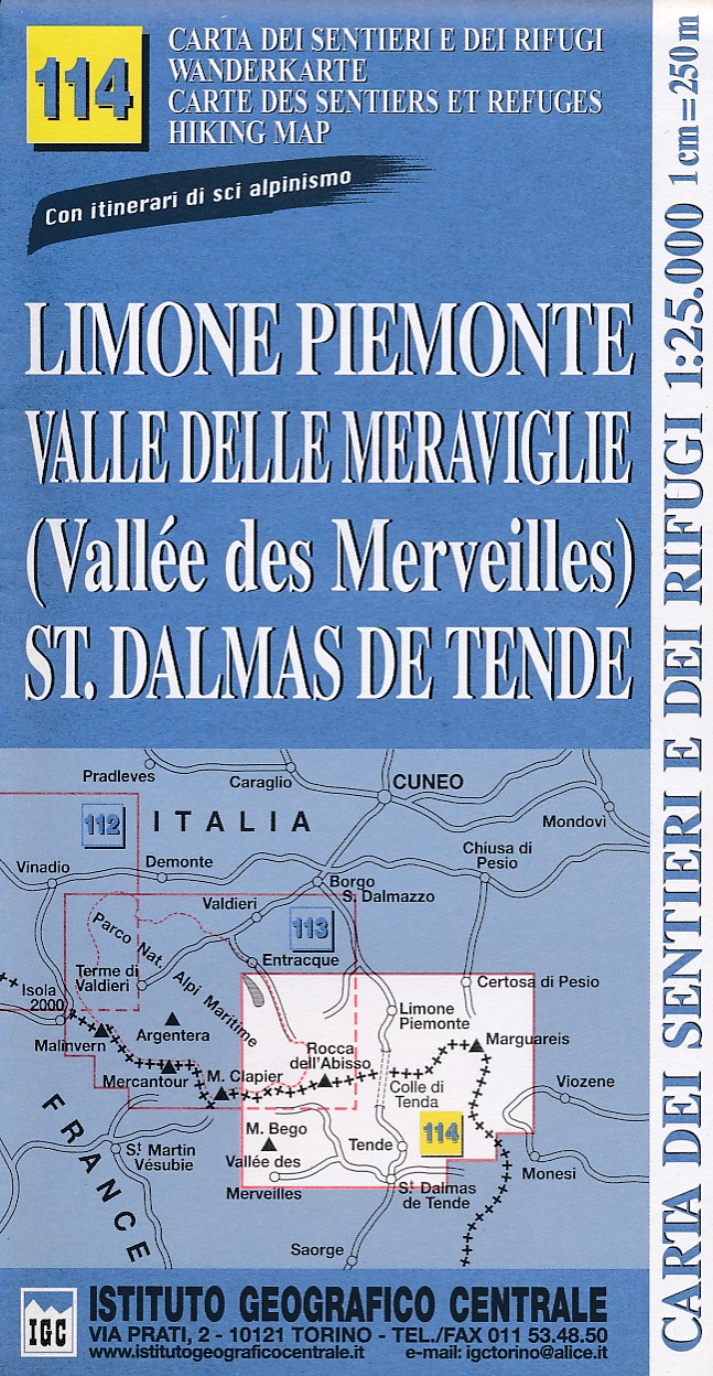
- Limone Piemonte - Vallée des Merveilles 25K IGC Map No. 114
- Limone Piemonte - Vallée des Merveilles area at 1:25,000 in a series of contoured, GPS compatible walking maps from the Turin based Istituto Geografico Centrale, highlighting hiking trails including long-distance routes, ski routes and alpine accommodation. Maps in this series have contours at 25m intervals, enhanced by shading and graphic... Read more

De Zwerver
Netherlands

Stanfords
United Kingdom
- Finale Ligure - Alassio - Savona IGC 15
- The coast of the Italian Riviera around Albenga, Alassio and Savona in a series contoured hiking maps at 1:50,000 with local trails, long-distance footpaths, mountain accommodation, etc. from the Turin based Istituto Geografico Centrale.Maps in this series have contours at 50m intervals, enhanced by shading and graphic relief. An overprint... Read more
De Zwerver
Netherlands
De Zwerver
Netherlands
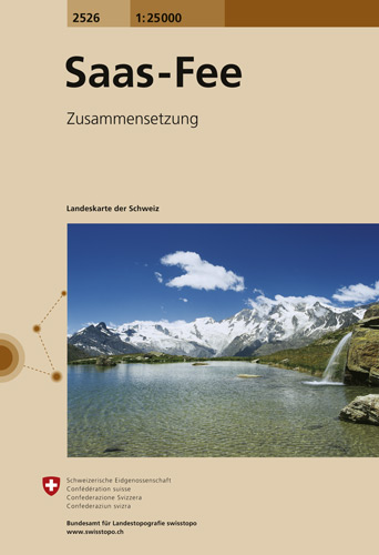
- Wandelkaart - Topografische kaart 2526 Saas - Fee | Swisstopo
- Map No. 2526, Saas-Fee, in the topographic survey of Switzerland at 1:25,000 from Swisstopo, covering the central part of the Mischabel range and both sides of the two adjoining valleys: the Mattertal between Zermatt and St Niklaus and the Saastal from north of Saas-Balen to the Mattmark Reservoir. Please note: Zermatt is at the southern edge... Read more

Stanfords
United Kingdom
- Saas-Fee Swisstopo 2526
- Map No. 2526, Saas-Fee, in the topographic survey of Switzerland at 1:25,000 from Swisstopo, covering the central part of the Mischabel range and both sides of the two adjoining valleys: the Mattertal between Zermatt and St Niklaus and the Saastal from north of Saas-Balen to the Mattmark Reservoir. Please note: Zermatt is at the southern edge... Read more

De Zwerver
Netherlands
- Wandelkaart 07 Valli Maira, grana e stura | IGC - Istituto Geografico Centrale
- Maira, Grana and Stura Valleys, map no. 7, in a series contoured hiking maps at 1:50,000 with local trails, long-distance footpaths, mountain accommodation, etc. from the Turin based Istituto Geografico Centrale covering the Italian Alps and Piedmont, the lakes and northern Lombardy, and the Italian Riviera.The maps have contours at 50m... Read more

Stanfords
United Kingdom
- Maira, Grana and Stura Valleys IGC 7
- Maira, Grana and Stura Valleys in a series contoured hiking maps at 1:50,000 with local trails, long-distance footpaths, mountain accommodation, etc. from the Turin based Istituto Geografico Centrale.Maps in this series have contours at 50m intervals, enhanced by shading and graphic relief. An overprint highlights local footpaths and... Read more

De Zwerver
Netherlands

Stanfords
United Kingdom
- Susa, Chisone & Germanasca Valleys: Sestiere - Sauze d`Oulx - Bardonecia 50K IGC Map No. 1
- Susa, Chisone and Germanasca Valleys, with coverage including Sestiere, Sauze d`Oulx and Bardonecia, in a series of contoured hiking maps at 1:50,000 with local trails, long-distance footpaths, mountain accommodation, etc. from the Turin based Istituto Geografico Centrale.Maps in this series have contours at 50m intervals, enhanced by shading... Read more

De Zwerver
Netherlands
- Wandelkaart 06 Monviso | IGC - Istituto Geografico Centrale
- Monviso / Monte Viso cross-border area with coverage from Châteaux Queyras to Sampeyre and from the Grand Queyron to the Aiguille de Chambeyron in a series contoured hiking maps at 1:50,000 with local trails, long-distance footpaths, mountain accommodation, etc. from the Turin based Istituto Geografico Centrale.Maps in this series have contours... Read more

Stanfords
United Kingdom
- Monviso IGC 6
- Monviso / Monte Viso cross-border area with coverage from Châteaux Queyras to Sampeyre and from the Grand Queyron to the Aiguille de Chambeyron in a series contoured hiking maps at 1:50,000 with local trails, long-distance footpaths, mountain accommodation, etc. from the Turin based Istituto Geografico Centrale.Maps in this series have contours... Read more
De Zwerver
Netherlands

Stanfords
United Kingdom
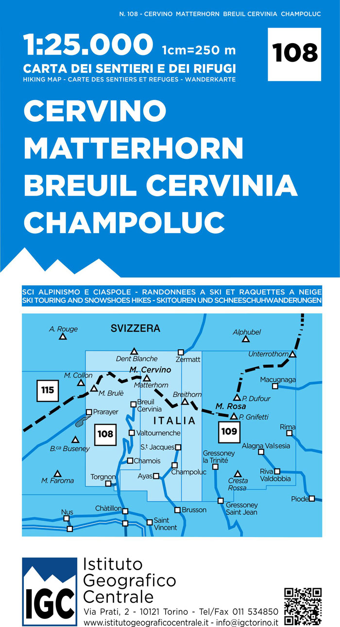
- Matterhorn / Cervino - Breuil Cervinia - Champoluc IGC 108
- Matterhorn/M. Cervino - Breuil-Cervinia - Champoluc area at 1:25,000 in a series of contoured, GPS compatible walking maps from the Turin based Istituto Geografico Centrale, highlighting hiking trails including long-distance routes, ski routes and alpine accommodation. Maps in this series have contours at 25m intervals, enhanced by shading and... Read more
De Zwerver
Netherlands

Stanfords
United Kingdom
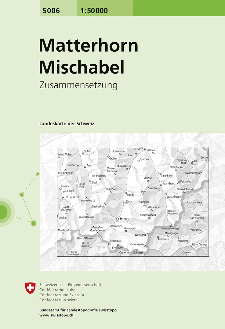
- Matterhorn - Mischabel Swisstopo 5006
- Matterhorn - Mischabel area, map No. 5006, in the standard topographic survey of Switzerland at 1:50,000 from Swisstopo, i.e. without the special overprint highlighting walking trails, local bus stops, etc, presented in Swisstopo’s hiking editions of the 50K survey. The map covers the whole of the Mattertal and Saastal valleys with Zermatt,... Read more

De Zwerver
Netherlands

Stanfords
United Kingdom
- Ivrea - Biela - Lower Aosta Valley 50K IGC Map No. 9
- Ivrea - Biela - Lower Aosta Valley area in a series contoured hiking maps at 1:50,000 with local trails, long-distance footpaths, mountain accommodation, etc. from the Turin based Istituto Geografico Centrale. Maps in this series have contours at 50m intervals, enhanced by shading and graphic relief. An overprint highlights local footpaths and... Read more
De Zwerver
Netherlands

Stanfords
United Kingdom
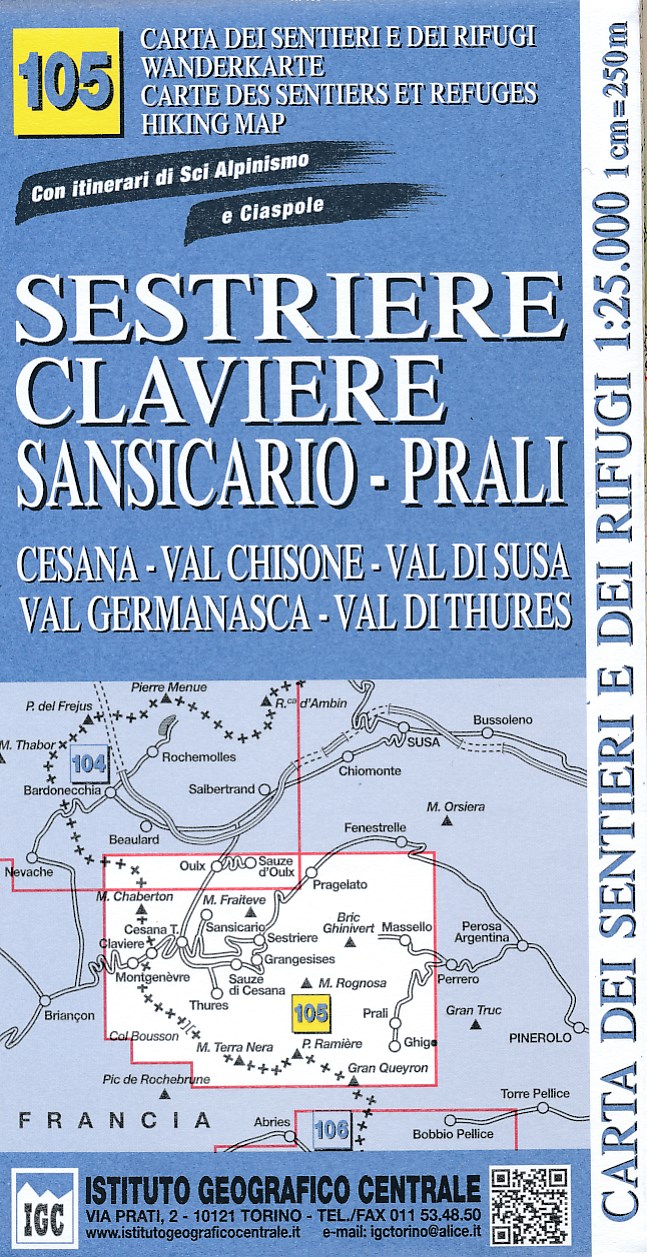
- Sestriere - Claviere Sansiciaro - Prali 25K IGC Map No. 105
- Sestriere - Claviere - Prali area at 1:25,000 in a series of contoured, GPS compatible walking maps from the Turin based Istituto Geografico Centrale, highlighting hiking trails including long-distance routes, ski routes and alpine accommodation. Maps in this series have contours at 25m intervals, enhanced by shading and graphic relief for very... Read more
De Zwerver
Netherlands

Stanfords
United Kingdom
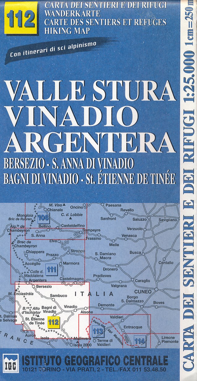
- Valle Stura - Vinadio - Argentera IGC 112
- Valle Stura - Vinadio - Argentera area at 1:25,000 in a series of contoured, GPS compatible walking maps from the Turin based Istituto Geografico Centrale, highlighting hiking trails including long-distance routes, ski routes and alpine accommodation. Maps in this series have contours at 25m intervals, enhanced by shading and graphic relief for... Read more
De Zwerver
Netherlands

Stanfords
United Kingdom
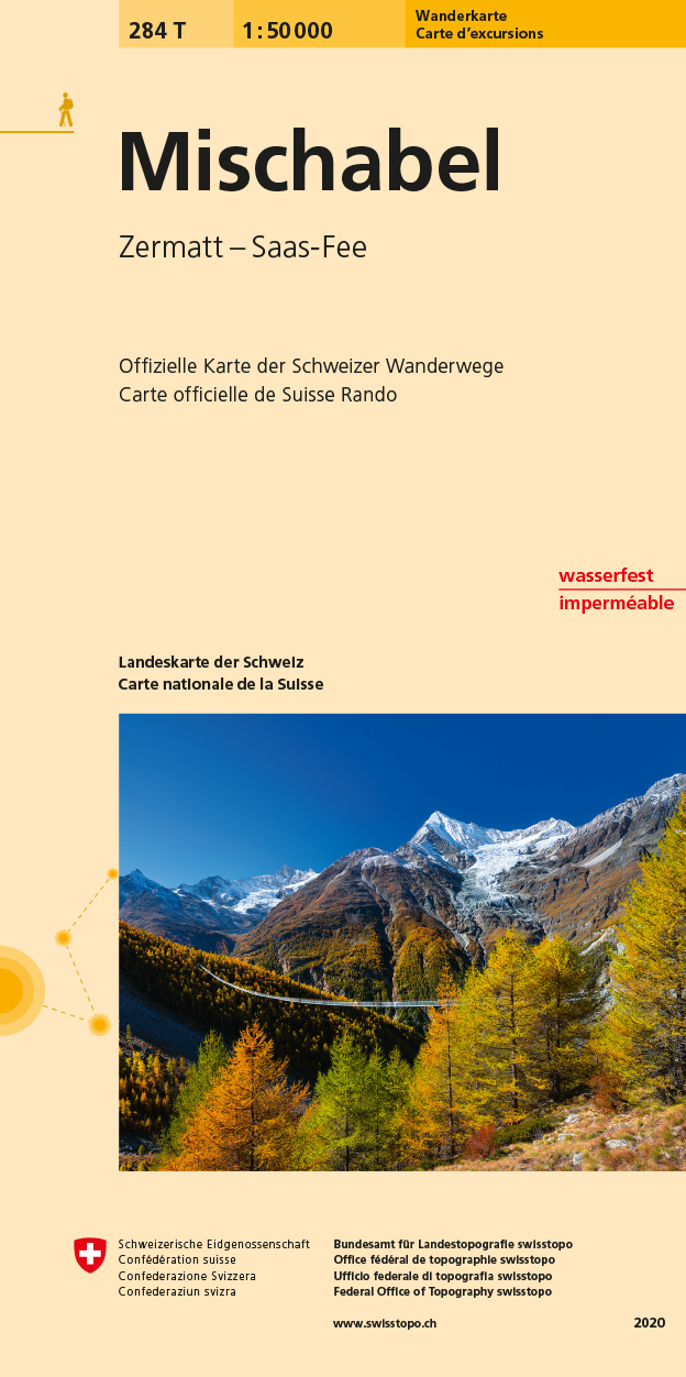
- Mischabel Swisstopo Hiking 284T
- The Michabel range, map No. 284T, at 1:50,000 in a special hiking edition of the country’s topographic survey, published by Swisstopo in cooperation with the Swiss Hiking Federation. The map covers most of the Mischabel range with the southern part of the Mattertal including Zermatt and Randa, the Saastal with Saas Fe, Theodul Pass, Monte Rosa... Read more
